Once all the kids had finished their Christmas party, the
camp site was deserted except for the German couple Rolf and Isobel, and their
daughter Ellie, so we had a nice quiet night beside the sea.
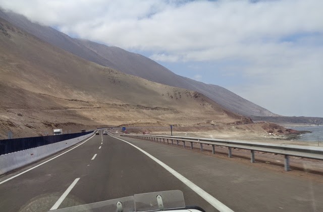
On our left, all the way south, are the high rock dunes
that form the barrier between the ocean and the Atacama. And on the right is the beach – But it is not
just beach – It is a wild, unpopulated, sea bird ridden, pelican covered, salt
mine included, Guano covered 200 km stretch of ocean front that if it were
anywhere else in the world would have high rise hotels and tourists
everywhere. But here in Chile, it is
still a wonderful, unspoilt stretch where camping is allowed just about
everywhere, and where friendly people in little wooden empanada and marisco huts
sell the most delicious food, and where the smell of sea bird poop and rotting
seaweed are more prevalent ! I found it
delightful – And could happily come back and spend a week or so just wandering
aimlessly down the coast, camping where ever you felt like it, right beside the
ocean. Personally, I found it a little
bit of heaven – While she thought it was pretty to see, Janet felt it was too remote, too wild, and couldn’t
imagine spending even one night here !
It wasn't long before we started seeing all this white
stuff beside the road – Looked like salt – And when I jumped out and picked
some up and licked it, it tasted like salt too !! Several evaporative salt “farms” down the
coast, and the trucks that move it around seem to loose enough in the wind that
there is a film of white salt on the edge of the road for miles !!
Then there is a smell of Guano – Apparently in the past
it was quite a big business down here, and there are several places where they
used to collect it for fertiliser. I
believe the locals still collect it for their own use, but it is no longer mined
/ farmed commercially. But there are so
many seabirds and pelicans on this coast line that many of the rocks are white
from their poop – A stark contrast to the usually dark grey rocks
elsewhere. There is even one large
island we saw with a big hole in it – Maybe this was one of the places where
they were digging it out ?
We found a place to stop for lunch down by the sea –
Totally deserted, and you could hardy even see the road from where we
were. Just a top spot.
Went through a smart tunnel, and then we came to
Tocopilla, where there was a superb golf course laid out in the sand, with
rocks making the fairways and sandy “browns” instead of greens ! Reminded us of Dubai in the early days ! And all the way down the coast there are
hundreds of vultures with their red heads (or are they condors ???) just
soaring gracefully in the thermals that are plentiful along the cliffs. At times they were soaring along beside us,
without a care in the world !
After some 200 kms of great road by the coast, we dropped into Tocopilla town, and it just
seemed like a rather scruffy port.
Luckily the road we wanted turned eastwards here, and we followed it,
climbing very quickly from sea level up through gorges to 2999 metres. And at the top, we were back in the Atacama
desert – As mentioned, not the most exciting piece of road to drive, but we persevered
and after about 140 kms we came to Chuquicamata copper mine – or rather the
piles of dirt that had been removed from this, one of the largest open cut
copper mines in the world. We tried to
drive up to it to see if we could see more, but no luck - One has to do a tour to see more, and being
a weekend at the moment, no tours !
Apparently the hole in the middle is over 1200 metres deep – That makes
it deeper than even Colca Canyon where we were just a few days ago ! Amazing.
After that, it was a short drop into Calama where we
intended to spend the night. All we saw as we drove through were big malls and
supermarkets, and talking to some German cyclists we met, they are stocked with
everything you can think of from overseas – Driven by the mining revenues
! We did eventually find our camp site,
although not without the frequent drama of the Co-ordinates taking us to the
wrong side of the area, so we were looking over the back fence, but couldn’t find
our way in !! When people plot
coordinates for a place, they really need to do it on the street directly
outside the location, and not from inside the location, otherwise these
senseless Sat Navs may try to take you to the compass point via the wrong route
!! Anyway, pleasant camp site, and some
wifi (although it took a while to get going !), so blog updated !!
Pics are here : -
https://picasaweb.google.com/117739775480775657932/0160IquiqueToCalama?authkey=Gv1sRgCJyr1b_u3PLlggE#


More on my 2000 trip. I flew from Arica to Calama and my driver and new interpreter picked me up and looked after me for four days. Then we saw the Salar de Atacama, Tocanau, San Pedro, Dead Valley, El Tatio geyser area, Pukara de Quitor, Catorpe and Tular. Next stop was tour of Chuquicamata before return to San Pedro. At that time they claimed the mine pit was 850 metres deep and the mine yielding 640,000 tonnes of copper per year. Lots of stuff to see in the whole area including other pukaras.
ReplyDelete